Trail Review: Gitchi-Gami Trail (Gooseberry to Split Rock)

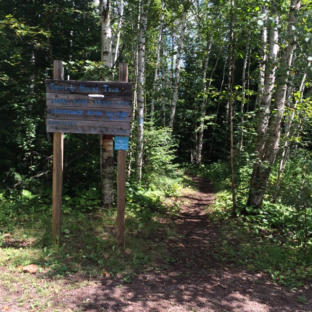
The Gitch-Gami State Trail is a paved trail with segments scattered along the North Shore. Its intended route, when finished, will run from Two Harbors to Grand Marais (89 miles, I guess), but right now it only has a few sections.

I ran the section from Gooseberry Falls State Park to Split Rock Lighthouse State Park, which is 8.1 miles, if you start at the actual trailhead. The trailhead is located at a picnic area a bit over a mile down the road through the state park (actually the terminus of the road), so a State Parks vehicle pass is necessary. The route is a bit shorter if you start near the Visitors’ Center – the trail crosses the road near the entrance to the park, so parking alongside the road (for free – and by the road I mean the one inside the park, not Highway 61) and jumping on the trail there will save about 1.1 miles.

ggtrailalt

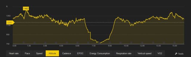
This is the elevation map of the trail (it’s from my GPS watch, so I’m sure there are some errors). It looks pretty jagged, but note the scale on the y-axis. That flat little part at the beginning is the section of the trail that winds from the trailhead back to the park entrance (at about 1 mile) – after that, the trail crosses Gooseberry Falls (the bridge has the potential to be a bit crowded) and then there’s more climbing up to the highest point of the trail segment. It’s not exceptionally steep, but it’s still about a mile of uphill running, right at the beginning of the run.

A lot of the trail is along Highway 61, so it isn’t secluded or exceptionally peaceful. On a busy weekend day in the summer or early fall, there will be a lot of traffic, and probably a lot of bikers. (I ran on a Sunday late afternoon, so it was quieter.) This also means the trail is fairly exposed, so there’s not a lot of shade. There are a few short, blessed sections of shade, but overall it’s not a woodsy trail.

There are several sections with nice lake views that are very tempting to a runner who just wants to be done. Come, sit at my picnic table, enjoy listening to the waves, these spots seem to say. Stop torturing yourself, aren’t you hot? Look at these nice, shady trees. If I wasn’t such a businesslike runner, I’d listen. The first of these sections comes after the first big descent.

About 4 miles in, the trail reaches the Twin Points Beach public access. This is an alternative spot to start the a run, one I am going to consider for the future when I do other segments – and I’d also like to explore the beach. It provides a brief respite from the sun, before dumping you back out along the highway.

Shortly after that, the trail descends to the mouth of the Split Rock River. I wanted to veer off the trail and right into the lake, it looked so cool and clean, with a typical North Shore rocky beach. Instead I endured a series of ascents for the final 2 miles (give or take) of the trail segment. This section separates from the highway, so it’s a bit more secluded. It finally winds its way down into Split Rock Lighthouse State Park. It does not actually end at the lighthouse, it ends before the lighthouse, at the trail center near the campground.

I like this trail when I want to get out of the city and my typical road routes, but I still want easy to manage terrain. I actually did it as an out and back for a long run (I prefer the Split Rock to Gooseberry direction) and found it really pleasant, except for the long periods of exposure to the sun, but that would be the same on a road run.

I’m looking forward to running additional segments of the trail, although I don’t know if I’ll venture beyond the Silver Bay endpoint – for a paved trail along a highway, it doesn’t seem worth driving all the way to Schroeder or Lutsen. (If I learn those segments are more scenic, I’ll give them a try, otherwise I’ll have to wait til I’m up there for another purpose.)

Trail Review: SHT Cramer Rd to Temperance River

I haven’t done a trail review in awhile, since many of my runs have been either on the same portions of trails I run over and over again, or they don’t have definitive starting/stopping points.

Over the weekend, I ran the first 8 miles of the Moose Mountain Marathon course, starting at the Cramer Rd trailhead in Schroeder, MN.

cramerrd

The trail starts off with some rocks and roots, but nothing overly technical, and remains fairly runnable for several miles. There are a few ups and downs in the first 2 miles, but nothing exceptionally tiring. There are a few places where the entire width of the trail is rock (as in, one single slab, not as in many small rocks), which I don’t like, due to the lack of traction. If the course is dry and mud-free, it’s not a big deal, but I did find it slick in spots since it rained while I was out running. Some of the plank bridges also got a little slippery, in fact I nearly twisted an ankle sliding sideways off of one. I am sure in drier conditions they are fine, although the wood is well-worn so I did find I was struggling with traction even on drier boards.

After about 3 miles, the trail starts to follow the Cross River, and that is some of the most pleasant running I’ve ever had. The trail is relatively flat and easy to traverse along the river, with a few tough spots, but the sound of the river rushing by is heavenly. The trail crosses the Cross River at a bridge 5.3 miles in. The ascent out of the river is a bit steep at first, with a ladder to climb, but it is not overly difficult after that point.

The descent down to the Temperance River, which comes about a mile and a half after the Cross River bridge, is fairly steep and lasts for about a mile. The next trailhead is at the end of the descent, but I continued along the trail down to the bridge crossing the river, which is about 3/4 mi past the parking lot. The trail follows the Temperance River fairly closely, with lots of great views that I did not photograph, I am very sorry. It’s worth seeing in person. It is a pretty popular spot along the SHT, so I had to dodge a few groups of hikers as I went along, and then encountered all of them again when I turned around.

Speaking of turning around: taking this hike in reverse is much, MUCH more difficult. The long descent to the river turns into a long, steep climb that seems endless. I tried not to think that it was almost over, that it couldn’t keep going, but at times I got frustrated. I didn’t stop, which was good, but I lost all energy and will to keep moving once I got to the top. Or what I thought was the top, which wasn’t, because after maybe 0.2 miles, I had another little climb. It was a little blip, but for someone already beaten down by the trail, it felt like a lot. There seemed to be more uphill than I thought there would be, since the descent coming out had been more gradual. I was feeling it on the way back, that’s for sure. I pulled it together for the final 3 miles, after eating some food and catching some easy sections of the trail.

Despite the frustrating climb, this is a new favorite section of the Superior Hiking Trail, thanks to the 2 miles along the Cross River and the portion along the Temperance River. Running from Cramer Rd to Temperance was significantly more enjoyable than running the opposite way, but there was no way to avoid that, since I was running alone.

Regarding the Moose Mountain Marathon in particular:

Here’s the race elevation profile, with the section I ran highlighted. (The image is from the Superior Fall Trail Races site):

MMM1

So, it’s the easy portion of the race. Look at that ascent out of Temperance heading toward Carlton Peak. Great googly moogly, that will never end.

This is the actual elevation captured by my GPS (remember the first 8 is the marathon course, the second 8 is my return trip, not the next 8 of the MMM). I think the narrower scale of the map gives a clearer picture of the “feel” of this section of the race, although it sure doesn’t make that climb look any better. There’s a slight error in the data on the descent into Temperance River – the profile in the ascent is much more accurate. Yes, it does feel like going straight up, although I’m sure other races have steeper sections than this.

MMM2

Trail Review: Westwood Hills Nature Center (Spring)

These trails aren’t in Duluth, but they are in my hometown and close to my heart. I grew up going to Westwood Hills Nature Center on school field trips, for summer camps, and for other educational activities. We once went and learned how to make a quinzhee hut, and my dad ended up building one in our front yard.

The nature center has changed a lot over the years, in a good way. There are more trails (I think), more observation spots, and apparently there is a waterfall. I didn’t realize this til after I left or I’d have checked that out. The biggest change is the wetlands area, known as the “Westdale Ponds,” which was annexed at some point unknown to me. When I was growing up, the Westdale Ponds area was actually Westdale Park, and was my neighborhood playground.

I hit all the major trails in the park (all the ones called out on the map), some of them more than once, and even then I only ended up running a little over three miles. That’s the big downside to the park: the trails are short.

It’s right in the middle of a first-ring suburb, so that’s expected. I thought the Marsh Trail (around the lake) was a little bit longer, but it’s only a mile and a half. A person could do worse than doing 1.5 mile laps around the Marsh Trail, which alternates between packed dirt paths, dirt/gravel mixed paths, and boardwalk as it circles the lake. I love running the boardwalk, especially through the marshes; I could hear all kinds of bird noises as I shuffled along.

The trails are non-technical; besides the previously-described Marsh Trail, there’s the Basswood Trail and Pine Trail; both are much shorter than the Marsh Trail and are mostly a dirt or dirt/woodchip mix. The Marsh Trail is flat, but the Basswood and Pine Trails go up and down the hill that makes up the eastern edge of the park.

The trails are not actually quiet, as Hwy 394 goes right by the north side of the park. There wasn’t really a place in the park where I didn’t hear the highway. Maybe on the very edge of the Prairie Trail (which is a very short trail that looks out over the entrance to the park), but I wasn’t thinking about that at the time and so I don’t remember. I still heard plenty of bird calls, so it’s still a nice experience, but I just wish I didn’t have to hear the cars.

I didn’t take any pictures because I didn’t bring my phone along (I don’t wear headphones when trail running), but I will be back there this summer for sure and will take some pictures. There wasn’t any snow, only a bit of mud, but the trails were kind of brown and blah. In the summer, when the trees have leaves and the surrounding neighborhood is a bit more obscured, it’s a lot more photogenic.

Westwood Hills Nature Center has nice, short trails, perfect for an easy mileage day, or for a day when time’s limited but the roads don’t seem appealing. I can see myself doing several loops around the lake on a day when I need to squeeze in a run but I don’t want to get too far from my car, or when I’m not sure how fast I feel like running and therefore am not sure what kind of mileage I should attempt. Despite the unfortunate highway noise, it’s still a great place to enjoy nature in the suburbs. Go there even if you don’t want to run, just to take a quick hike or to learn something fun about maple syrup or bird calls or canoeing.

Trail Review: Minnesota Point (Winter)

I really, really love this trail, but it does have some drawbacks.

This is not one of the drawbacks.

The Minnesota Point trail is a mix of access road, single-track, and wider trails that extend to the very tip of the spit. It’s somewhere between 4 and 4.6 miles, depending on which route you take. I took a longer way out than I did back, hugging the edge of the Superior Bay side, and then cutting back in at Point Zero Lighthouse. The ruin of the lighthouse actually once stood at the tip of the spit, but sand deposits from the lake changed the location of the harbor entry. I saw it on an episode of Lost Duluth on public television last summer, which was what prompted me to head out there in the first place.

The major drawback to the trail is the terrain. Much of it is sand. Running in sand is annoying. I am sure that it was a good strength workout for my legs, or something, but it is still incredibly annoying. I had hoped since it was winter, the sand would be compacted and covered in a bit of snow, but that was not the case.

All the snow had blown off the trail, I think. That’s the other drawback to the trail in winter. The vicious wind. At the beginning of the run, I was questioning if I was appropriately dressed, and if I had made a horrible mistake. One side of my body was being pummeled. The trail heads into the woods early on into the run, so I was somewhat shielded, but it was whistling and howling above me through the treetops, which made me imagine it was colder than it was.

Those are the only two drawbacks to the trail (in winter). The rest is beautiful. There are a few small “mounds” but no great changes in elevation, the sand was a little bit compacted so it was easier to run in than it is during warmer temperatures, and the scenery is amazing. Some of the trail is in the trees, other parts along the shoreline, and the end of it is…

…even better in person. The only downside is having to look at Wisconsin sometimes.

It’s still better in the summer (despite the sand), because the sound of the waves against the shore is heavenly, but it is a great place for a hike or a run. It is not a great place for speedwork or tempo runs. I don’t know what the trail grooming is like if there is snow, I’ll try to get out there when/if it snows a bit more to see. The trail, other than the sand, is not difficult; there aren’t trees or boulders or other obstacles. In a few spots the trail gets a little overgrown, but it’s not too hard to push a few branches out of the way.

A great long run would be an out-and-back of the entire strip of land, from the lift bridge to the tip and back again. I have run from the entrance to the park to the lift bridge and back (which is about 7.5 mi) but I’ve never put the two together. Sounds like a bucket list item for a time with warmer temps and a better training base.

Trail Review: Guardrail at Hartley Nature Center (Winter)

I gave the Guardrail another shot on Saturday, after my first whack at it left me a bit puzzled. This time I didn’t wander off the trail onto Blue Pots, which, it turns out, dumped me off on the trail headed in the direction I’d already traversed when I ran on it before.

Guardrail is a single-track, two-way, packed and groomed, multi-use, technical trail at Hartley Nature Center in Duluth. It winds its way through the woods like the switchbacks on Berthoud Pass in Colorado. Whoever designed this path made the most of the space available in the park, which I appreciate.

Since I am a little bit lazy, I don’t even mind stepping off the trail for the occasional cyclist. All of the cyclists I’ve encountered have been friendly and don’t come whipping around corners out of nowhere, so I am more than happy to accommodate them. I was lucky that most of them were coming from the opposite direction, so I could see them coming and pick a spot to let them pass. I hope in the summer there isn’t a significant uptick in bike traffic on the trail, but if I extrapolate my experiences last fall at Hartley (on different trails), that would seem unlikely.

The trail is accessible by taking the Old Hartley Road Trail to Tunnel Trail to Fisherman or Rhamnus. I ended up getting on the trail via Fisherman and getting off again at Rhamnus, which is the clockwise version of the loop.

Let me take a moment to mention how much I love the Tunnel Trail.

I could run that forever.

I enjoyed the twists and turns of Guardrail, even though it felt at times like it was a net uphill course, which it obviously can’t be since it’s a loop. What goes up, must come down. There were exposed icy patches on some of the steeper parts of the trail, not all of which were immediately visible, and so I was as conservative on the descent as I was on the ascent. I may or may not have briefly thrown out my heart rate training restrictions to fly across a few of the more gentle declines. They were just too good.

The trail, as I took it, ended up being about 4.9 miles, which makes it a nice medium (for me) run. The other trail I’ve run at Hartley, Root Canal, is a bit shorter, so now I have a few options at the same park. I can also combine Root Canal and Guardrail for a long run, something I’m looking forward to as I gradually increase my mileage.

Overall, this trail is one of my favorites within the city limits, with lots of access points, including Howard Gnesen Rd, Marshall St., and North Road, so it’s not necessary to drive all the way to Hartley if there’s a closer trail spur. I almost ended up living out this way, as I looked at a house to rent nearby. The house ended up being small, with an incredibly weird layout, and a trompe l’oeil “basketball court” scene in the basement, and I am glad I didn’t end up there, but I suppose a small consolation would have been easy trail access.

Trail Review: Bagley Nature Area (Winter)

Saturday I couldn’t stand another day on the treadmill, so even though it was -2 when I got up, I told myself if it was in the high single digits by noon, I would get outside for my run. It was, so I did.

I headed out to Bagley Nature Area, on UMD’s campus. A small portion of the trail is on the Superior Hiking Trail as it winds its way through the city. The trail is not paved, but is not particularly technical; there are no large rocks or tree roots or other obstacles. In the winter, its two main loops are groomed and there are classic x-c skiing tracks. There is a small hill where kids can go sliding/tubing that might cause some traffic jams or collisions on the way on or off the loops. Since school is closed, there’s parking right near the trail. When school is open, the parking lot is for campus residents, so I don’t know what non-students do. Street parking is impossible during the weekdays when school is in session.

I wore my shoes chains, which gave me plenty of traction on the groomed and slightly packed trails. At times there was ice directly under the snow, so I was glad to have the extra traction and stability. There weren’t that many people out since it was cold: a couple other runners and a couple cross country skiers, plus the kids on the sliding hill.

Click here for a map of the groomed trails. The east loop is definitely the easier loop: it has a few very small hills, but nothing too challenging. In autumn I love the east loop because the trees are simply gorgeous and the trail is carpeted in leaves.

View this post on Instagram

A little serenity on #umd campus at #bagley between games.

A post shared by RWD (@runninwiththedogs) on

The west loop, while shorter in distance, is more challenging. The walking trail diverges from the ski trail for a bit, so it’s a little longer than 1.2k as shown on the map. Two cute wooden bridges cross over a little creek and back again. Once the loop rejoins the ski trail the path comes to a large hill. I mean, not large by Rocky Mountain standards or anything, but it’s a more difficult hill than might normally be found on a tiny, semi-urban loop. The scenery at the top of the hill is lovely, in the winter there’s even a glimpse of the lake, but for some reason every time I’m up there, a dog at one of the nearby houses is out and barks and ruins the serenity!

The loop comes back down along Junction Ave/St. Marie St., following the pond. The descent is more gentle than the ascent (note that I run the paths the same direction as the skiers), but along the pond I found the path was at its iciest and had to be cautious. Since the two loops come together on the north side of the pond, it’s easy to make a few figure 8 loops of the trail and turn a short trail into a good place for a medium-length run.

Bottom line: Bagley Nature Area has groomed trails, few flat stretches, and lots of trees. It’s a great place to go on days when I’m not sure how I feel, because the loop is so short it’s easy to tap out after a few miles if it’s not my day. It is not a great place for speedwork or aerobic training, due to the large hill on the west loop.

Trail Review: Lakewalk (Winter)

I’m not sure if this review counts as a “winter review” since it’s not usually 26 degrees with scant snow cover in January here, but it will for now. I’ll probably re-review it or update this review when we’ve gotten more snow. I will not be re-reviewing it when it’s colder because I will not be out there. Tomorrow the high is -5 so I probably won’t be out there anytime soon. I wore my shoe chains today and felt kind of stupid because it wasn’t very slick at all and the trail was almost entirely clear.

The Lakewalk is about 2.3 miles long and is a nice out-and-back. The terrain is predictable and there are only few small hills, so it’s a good trail to use as a benchmark for improvement. It also starts/ends right in Canal Park and winds through the backyard of most of the hotels and Leif Erickson Park, so it is always going to have people on it. It’s multi-use, with a boardwalk for walking along a portion of it, and blacktop for running (and walking past a certain point) or biking.

It’s unbelievably gorgeous on one side. I took this at the finish of my run today. It was snowing when I started and I was hoping to take a lovely picture of snow on the lake, but it stopped before I was done.

CanalPark

It also has some major drawbacks. Even though there’s a lovely view of the lake, it’s not a serene path. The freeway goes right alongside, as does the scenic railroad. The railroad went by me last summer when I was slogging along (the same night I found the cat) and I felt like an idiot. Past the two mile mark there’s some kind of sewage storage building that smells unpleasantly as you pass by. The smell doesn’t last very long and isn’t too terrible, but it detracts from the experience.

Parking in the public lots in Canal Park is free during the winter, and the lot at the far end of Canal Park by the Army Corps of Engineers museum is basically trailside parking. If you time your run right, you can watch a ship go through the canal with 200 of your closest tourist friends. Caribou Coffee and Amazing Grace bakery are nearby to grab a coffee or snack post-run.

Bottom line: the Lakewalk is a nice, predictable, non-technical trail with beautiful views of Lake Superior, but can be a little crowded or noisy.