I haven’t done a trail review in awhile, since many of my runs have been either on the same portions of trails I run over and over again, or they don’t have definitive starting/stopping points.
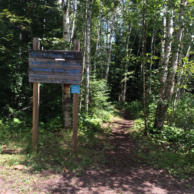
Over the weekend, I ran the first 8 miles of the Moose Mountain Marathon course, starting at the Cramer Rd trailhead in Schroeder, MN.
The trail starts off with some rocks and roots, but nothing overly technical, and remains fairly runnable for several miles. There are a few ups and downs in the first 2 miles, but nothing exceptionally tiring. There are a few places where the entire width of the trail is rock (as in, one single slab, not as in many small rocks), which I don’t like, due to the lack of traction. If the course is dry and mud-free, it’s not a big deal, but I did find it slick in spots since it rained while I was out running. Some of the plank bridges also got a little slippery, in fact I nearly twisted an ankle sliding sideways off of one. I am sure in drier conditions they are fine, although the wood is well-worn so I did find I was struggling with traction even on drier boards.
After about 3 miles, the trail starts to follow the Cross River, and that is some of the most pleasant running I’ve ever had. The trail is relatively flat and easy to traverse along the river, with a few tough spots, but the sound of the river rushing by is heavenly. The trail crosses the Cross River at a bridge 5.3 miles in. The ascent out of the river is a bit steep at first, with a ladder to climb, but it is not overly difficult after that point.
The descent down to the Temperance River, which comes about a mile and a half after the Cross River bridge, is fairly steep and lasts for about a mile. The next trailhead is at the end of the descent, but I continued along the trail down to the bridge crossing the river, which is about 3/4 mi past the parking lot. The trail follows the Temperance River fairly closely, with lots of great views that I did not photograph, I am very sorry. It’s worth seeing in person. It is a pretty popular spot along the SHT, so I had to dodge a few groups of hikers as I went along, and then encountered all of them again when I turned around.
Speaking of turning around: taking this hike in reverse is much, MUCH more difficult. The long descent to the river turns into a long, steep climb that seems endless. I tried not to think that it was almost over, that it couldn’t keep going, but at times I got frustrated. I didn’t stop, which was good, but I lost all energy and will to keep moving once I got to the top. Or what I thought was the top, which wasn’t, because after maybe 0.2 miles, I had another little climb. It was a little blip, but for someone already beaten down by the trail, it felt like a lot. There seemed to be more uphill than I thought there would be, since the descent coming out had been more gradual. I was feeling it on the way back, that’s for sure. I pulled it together for the final 3 miles, after eating some food and catching some easy sections of the trail.
Despite the frustrating climb, this is a new favorite section of the Superior Hiking Trail, thanks to the 2 miles along the Cross River and the portion along the Temperance River. Running from Cramer Rd to Temperance was significantly more enjoyable than running the opposite way, but there was no way to avoid that, since I was running alone.
Regarding the Moose Mountain Marathon in particular:
Here’s the race elevation profile, with the section I ran highlighted. (The image is from the Superior Fall Trail Races site):
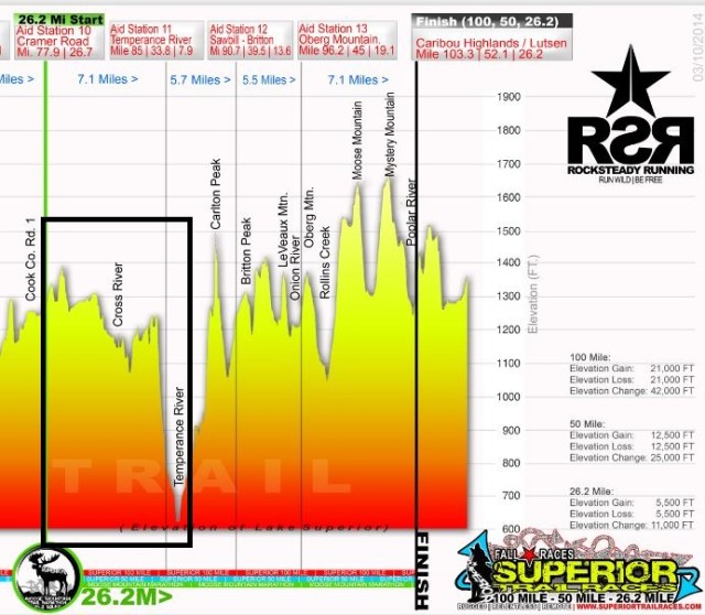
So, it’s the easy portion of the race. Look at that ascent out of Temperance heading toward Carlton Peak. Great googly moogly, that will never end.
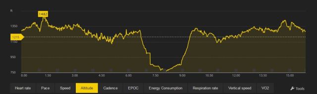
This is the actual elevation captured by my GPS (remember the first 8 is the marathon course, the second 8 is my return trip, not the next 8 of the MMM). I think the narrower scale of the map gives a clearer picture of the “feel” of this section of the race, although it sure doesn’t make that climb look any better. There’s a slight error in the data on the descent into Temperance River – the profile in the ascent is much more accurate. Yes, it does feel like going straight up, although I’m sure other races have steeper sections than this.

One thought on “Trail Review: SHT Cramer Rd to Temperance River”